Two Rivers Trail Project
Two Rivers Trail Components
- Phase I (Completed in 2006) – Levee-top trail between Tiscornia Park and State Route 160
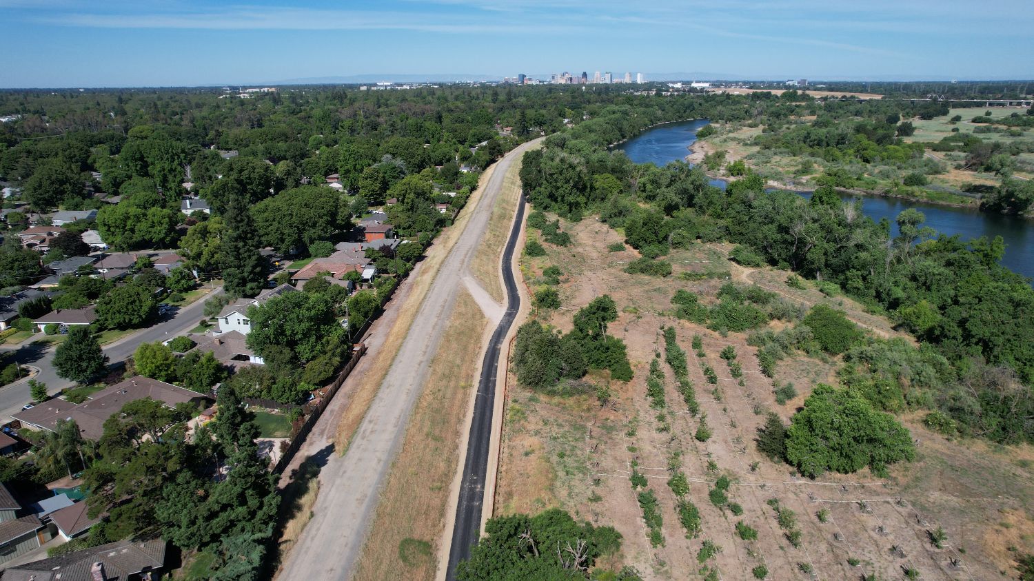
- Sutter’s Landing (Completed in 2016) – An additional segment of trail along the south bank of the American River from 28th Street to the eastern edge of Sutter’s Landing Park (completed as part of the American River Parkway Enhancements Project)
- Phase II (Construction Completed in 2024) – An additional 2.4 miles of trail that will connect to the existing County trail at the H Street Bridge, and ends at the UPRR eastern right-of-way line.
- Phase III (Planning and Design Underway in 2024 and 2025) – Additional trail segments and trail amenities that will close many of the existing gaps between the Phase I and Phase II trail segments.
- Phase IV (Feasibility Assessment Completed in 2024) – Trail crossing of the westerly UPRR tracks.
Overall Project Benefits
The Two Rivers Trail system will offer several benefits to the local community and surrounding area.
Safety
Based on data from the National Recreation and Parks Associations and local parks and law enforcement staff, bike trails tend to reduce crime by cleaning up landscape and attracting users to the trail for recreation and transportation. Additionally, the trail system integrates Crime Prevention Through Environmental Design – commonly known as CPTED
Property Value
According to the National Association of Home Builders, trails are the most desired community amenity that homeowners seek when buying a home. In fact, neighborhood trails located in various cities have reported an increase in property value ranging from 2 to 5 percent.
The City of Sacramento is working toward the completion of a continuous network of paved, accessible, multi-use trails that connect the existing Sacramento River and American River parkways. The Two Rivers Trail Project is an important piece of the evolution of the City’s trail system. Named for its origin at the confluence of the Sacramento and American Rivers, the Project began to take shape in 2001 with the completion of a Two Rivers Trail Concept Plan.
When complete, Two Rivers Trail will connect the system of pedestrian- and bicycle-friendly trails along both sides of the Sacramento and American Rivers.
Phase III – Planning & Environmental Underway
Two Rivers Trail Phase III will close the majority of gaps within the trail system, bringing the City one step closer to realizing the vision that was established over 20 years ago – a continuous network of multi-use trails that provides recreation and transportation options for the region.
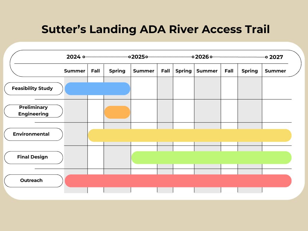
Phase III Anticipated Timeline
Efforts in each of the areas included in Phase III are underway concurrently, but due to unique constraints in each area the timelines are slightly different. The anticipated general timeline is as follows:
- Spring 2024 - Summer 2025: Feasibility Study & Prelim Engineering
- Winter 2024 - Fall 2025: Environmental Technical Studies & Permitting
- Fall 2025 - Spring 2026: Final Design
- Summer 2026 - Summer 2027: Construction, funding dependent
Phase III Project Update, Spring 2025
Progress continues for the Two Rivers Trail Phase III Project, getting closer to providing the final link in the Two Rivers Trail system within Sutter’s Landing Park. The draft feasibility study for Two Rivers Trail Phase III was completed in late 2024, and preferred alternatives have been developed following a comprehensive review and public engagement process. The preferred alternatives will be presented to Sacramento City Council in early summer 2025.
The next step for Two Rivers Trail Phase III is the preparation of a Subsequent Environmental Impact Report (SEIR) which will discuss the impacts of the preferred alternatives and provide CEQA clearance for Phase III and potential futures phases of the project. The SEIR is anticipated to be available for public comment by late summer 2025.
Phase III Components
- Connect Two Rivers Trail Phase II (currently under construction) with the eastern limits of the existing Sutter’s Landing Trail
- Create a new trail segment from 28th Street to the “landfill loop” (east of UPRR)
- Connect the Sac Northern Trail to Two Rivers Phase I
- Provide conceptual designs and early feasibility assessments for a crossing of the westerly UPRR tracks


Phase III Environmental
Notice of Preparation of a Subsequent Environmental Impact Report and Scoping Meeting for the Two Rivers Trail Phase III Multi-Use Trail Project
Review Notice of Preparation here .
Public Comment Period
- March 31, 2025 to May 1, 2025
Scoping Meeting
- 5:30-6:30 p.m.
- Wednesday, April 23, 2025
- Zoom link to be posted to cityofsacramento.gov/tworiverstrail in advance of the meeting.
Phase III Public Outreach
During the Phase III planning and design process, the project team will work closely with City residents, particularly those in areas surrounding the trails, to present project details and obtain public input.
- Alternatives Community Survey Findings Report (October 2024 ) - Thank you for your feedback on the potential Phase III alternatives.
- Active Transportation Commission presentation (August 2024)
- Transportation Planning News (August 2024)
- Sutter's Landing Regional Park Community Meeting #2 Notes (December 2024)
If you are interested in learning more about future project meetings and presentations or to share feedback on the alternatives, please e-mail us at tworiverstrail@cityofsacramento.org
Phase II - Complete
After years of design, planning and public engagement, the Two Rivers Trail Phase II construction was completed in 2024 and is now open to the public.
Phase II includes more than two miles of paved accessible pathway connection the trail system from the H Street Bridge to just east of Sutter’s Landing Park and the Business 80 freeway.
Provided below are previous public meeting presentations to provide additional background about Phase II components.
Two Rivers Trail Overview
Project-Related Documents
Provided below are a series of important documents and reports created either as part of the evolution of the Two Rivers Trail project, or in alignment with the vision of the project.
Reports and Documents
Sutter's Landing Regional Park: ADA River Access Trail Project
The City of Sacramento, Department of Youth, Parks and Community Enrichment received a grant to design an ADA accessible trail on the south side of the American River within the Sutter’s Landing Regional Park. The current, user-created access route from the parking lot to Sutters Landing Beach on the bank of American River is not ADA compliant.
Interested in learning more? Email tworiverstrail@cityofsacramento.org to be added to the project database.
Sutter's Landing ADA River Access Survey: Summary of Results
Thank you for your recent participation in the Sutter's Landing ADA River Access Trail Survey. There were a total of 180 survey responses, and the insight shared is helpful to the City and its engineering design team as this project moves forward.
ADA Trail Components
The project includes design of a formal ADA compliant trail with river and non-motorized boat launch access, development of a restoration plan for habitat that has been degraded by social trails, and development of interpretive signage for the new trailhead.
The design team is currently evaluating access alternatives and will base their recommendation on cost, hydraulic impacts, utility impacts, public engagement, resource/approval agency support, ease of access and environmental impacts.
ADA Trail Schedule
ADA Trail Funding
The City of Sacramento received public funding for the ADA River Access Trail from the Wildlife Conservation Board (WCB) for project design and environmental compliance. The source of construction funding needs to be identified.
ADA Trail Public Outreach
The project team has conducted site walks and participated in a community meeting, see notes below.
- July 22, 2024 Meeting - Friends of Sutter’s Landing (summary pending)
- August 19, 2024 Meeting - With Friends of Sutter’s Landing/Corey Brown (summary pending)
- December 12, 2024 - Community Open House with the Sutter’s Landing Park team
- January 3, 2025 - ARPAC
- January 23, 2025 - RPC