- Home
- ...
- Engineering
- Transportation Projects
- Two Rivers Trail Project
- City Departments
-
-
Community Development
-
Community Response
-
Convention and Cultural Services
-
Finance
-
Fire Department
-
Human Resources
-
Information Technology
-
Mayor and Council
-
Office of Public Safety Accountability
-
Office of the City Attorney
-
Office of the City Auditor
-
Office of the City Clerk
-
Office of the City Manager
-
Office of the City Treasurer
-
Police Department
-
Public Works
-
Utilities
-
Youth, Parks, & Community Enrichment
-
- Browse by categories
-
-
hiking Activities
-
pets Animals & Pets
-
domain_add Building & Planning
-
store Business
-
account_tree City Administration
-
category City Assets & Data
-
explore City Regions
-
diversity_4 Community Support
-
theater_comedy Culture & History
-
business_center Employment
-
directions Infrastructure
-
gavel Law, Code & Compliance
-
payments Money
-
park Outdoors & Sustainability
-
local_police Safety
-
directions_car Transportation
-
delete_sweep Utility Services
-
Use the menus above to navigate by City Departments or Categories.
- Convention and Cultural Services
- Arts and Culture
- Convention and Cultural Services
- Convention and Cultural Services
- Convention and Cultural Services
- Convention and Cultural Services
- Home
- Arts and Culture
- Arts and Culture
- Arts and Culture
- Arts and Culture
- Arts and Culture
- Convention and Cultural Services
- Access Leisure
- Recreation
- Youth, Parks, & Community Enrichment
- Community Engagement
- Community Engagement
- About YPCE
- Hart Senior Center
- Recreation
- Older Adult Services
- Youth, Parks, & Community Enrichment
- Long Range
- Youth, Parks, & Community Enrichment
- Recreation
- Recreation
- Home
- Youth, Parks, & Community Enrichment
- About YPCE
- About YPCE
- Older Adult Services
- Home
- Innovation and Grants
- Aquatics
- CCS Partners
- Innovation and Grants
- Convention and Cultural Services
- Community Engagement
- District 7 - Rick Jennings
- Request a Permit
- CCS Partners
- Fire Department
- About YPCE
- Recycling & Solid Waste
- Convention and Cultural Services
- CCS Partners
- Emergency Management
- CCS Partners
- Commercial Waste Services
- Home
- Recreation
- Access Leisure
- Recreation
- Recreation
- Recreation
- Specialty Parks
- Specialty Parks
- Permits for YPCE
- Recreation
- Youth, Parks, & Community Enrichment
- About YPCE
- Youth, Parks, & Community Enrichment
- Aquatics
- Home
- Animal Care
- Animal Care
- Community Development
- Animal Care
- Animal Care
- Animal Care
- Animal Care
- Animal Care
- Specialty Parks
- Animal Care
- Animal Care
- Accessory Dwelling Units
- City Government
- Community Development
- Building
- Contact CDD
- Building
- Building
- Building
- Building
- Business Waste Requirements
- Commercial Waste Services
- Maintenance Services
- Procurement Services Division
- Parks
- Utilities
- Public Works
- Engineering
- Fire Prevention
- Building
- Building
- Building
- Building
- Engineering
- Home
- Public Works
- Engineering
- Planning
- Fire Prevention
- Contact CDD
- Building
- Fire Prevention
- Engineering Programs & Services
- Fire Prevention
- Community Development
- Community Development
- Community Development
- Transportation
- Locate & Grow in Sacramento
- Planning
- Planning
- Planning
- Climate Action Initiatives
- Planning
- Planning
- Parks
- Community Development
- Community Development
- Planning
- List of City Manager's Office Projects and Programs
- Public Works
- Planning
- Planning
- Public Works
- Transportation
- Planning
- Planning
- Engineering
- 102-Acre Site
- Community Development Meetings and Hearings
- Major Planning Projects
- Locate & Grow in Sacramento
- Planning
- City Government
- Innovation and Economic Development
- Code Compliance
- Revenue Division
- Business
- Office of the City Manager
- Recycling & Solid Waste
- Business
- Business
- Procurement Services Division
- Revenue Division
- Business
- Revenue Division
- City Auditor Reports
- City Auditor Reports
- Cannabis Management
- Cannabis Management
- Business Operations Tax
- Cannabis Management
- Office of the City Manager
- Cannabis Management
- Cannabis Management
- Cannabis Management
- Parking
- COVID-19 Relief & Recovery
- Innovation and Economic Development
- Business
- Innovation and Economic Development
- Innovation and Economic Development
- Innovation and Economic Development
- Innovation and Economic Development
- Office of the City Manager
- Business
- Business
- Innovation and Economic Development
- Innovation and Economic Development
- Business
- Innovation and Economic Development
- Office of the City Manager
- Business
- Finance
- Accounting Division
- Police Services
- Procurement Services Division
- City Government
- Code Compliance Programs
- Code Compliance Programs
- Commercial Waste Services
- Procurement Services Division
- Procurement Services Division
- Home
- Commercial Waste Services
- Procurement Services Division
- Finance
- Finance
- Procurement Services Division
- Office of the City Auditor
- Office of the City Auditor
- Office of the City Auditor
- Accounting Division
- Office of the City Clerk
- Home
- About YPCE
- Diversity and Equity
- Records Management
- Office of the City Auditor
- Director Hearings
- Director Hearings
- Director Hearings
- District 1 - Lisa Kaplan
- District 2 - Shoun Thao
- City Auditor Reports
- Office of the City Clerk
- About YPCE
- Police Transparency
- Home
- Records Management
- Office of the City Manager
- Office of the City Manager
- Office of the City Manager
- Neighborhood Directory
- Neighborhood Directory
- Community Engagement
- Office of the City Manager
- Innovation and Grants
- Office of the City Manager
- Office of the City Manager
- Office of the City Manager
- Home
- City Government
- Engineering
- City Government
- Long Range
- City Government
- City Government
- City Government
- City Government
- Information Technology
- Camp Sacramento
- Parking
- About YPCE
- Finance
- Drinking Water Quality
- Office of Public Safety Accountability
- Police Services
- Police Services
- Marina
- Police Services
- Contact Us
- Police Services
- Utilities
- Pay Your Utility Bill
- Office of the City Clerk
- Home
- Mayor and Council
- Mayor and Council
- Mayor and Council
- Mayor and Council
- Mayor and Council
- Mayor and Council
- Mayor and Council
- Mayor and Council
- Mayor and Council
- Office of the City Clerk
- Mayor and Council
- Home
- Diversity and Equity
- Office of the City Auditor
- Office of Public Safety Accountability
- About the City Attorney's Office
- Office of the City Auditor
- Office of the City Auditor
- Police Department
- Maps and Geographic Information Systems
- Office of Public Safety Accountability
- Police Department
- City Government
- Office of the City Auditor
- 102-Acre Site
- 102-Acre Site
- 102-Acre Site
- Public Works
- Construction & Demolition Recycling
- About SPD
- Facilities & Real Property Management
- Public Works
- Adult Sports Activities and Resources
- Climate Action Initiatives
- Fleet Services
- Public Works
- Director Hearings
- Director Hearings
- Director Hearings
- Director Hearings
- General Plans
- Police Transparency
- Convention and Cultural Services
- Legislative Management
- Home
- Maps and Geographic Information Systems
- Office of the City Clerk
- Police Services
- Office of the City Auditor
- Office of Public Safety Accountability
- About the City Attorney's Office
- Office of the City Auditor
- Office of the City Auditor
- Police Department
- Maps and Geographic Information Systems
- Office of Public Safety Accountability
- Police Department
- City Government
- Office of the City Auditor
- Mayor and Council
- Mayor and Council
- Mayor and Council
- Mayor and Council
- Mayor and Council
- Mayor and Council
- Mayor and Council
- Mayor and Council
- Maps and Geographic Information Systems
- City Elections
- Police News
- Community Resources and Financial Empowerment
- Community Engagement
- Locate & Grow in Sacramento
- Major Planning Projects
- Engineering
- 102-Acre Site
- Community Development Meetings and Hearings
- Major Planning Projects
- Locate & Grow in Sacramento
- Planning
- Youth, Parks, & Community Enrichment
- Specialty Parks
- Long Range
- City Government
- List of City Manager's Office Projects and Programs
- Parking
- Transportation Projects
- About YPCE
- Home
- Engineering Programs & Services
- Maintenance Services
- City Government
- Older Adult Services
- Home
- Youth, Parks, & Community Enrichment
- About YPCE
- About YPCE
- Older Adult Services
- Home
- 102-Acre Site
- Long Range
- City Auditor Reports
- Priority Projects/Investments
- Innovation and Economic Development
- Diversity and Equity
- Join Sacramento Fire
- Innovation and Economic Development
- Transportation
- Responding to Homelessness
- Office of the City Manager
- District 5 - Caity Maple
- Office of the City Manager
- Police News
- Safety and Crime Prevention Tips
- Police Department
- Community Development Meetings and Hearings
- Diversity and Equity
- Older Adult Services
- Cannabis Management
- Office of the City Auditor
- Office of the City Auditor
- Human Resources
- Financial Empowerment
- Home
- Innovation and Economic Development
- Police Community Programs
- Community Response
- Community Response
- Workforce Development
- Police Community Programs
- Community Response
- Office of the City Manager
- Planning
- Housing
- Housing Development Toolkit
- Housing Development Toolkit
- Housing
- Housing
- Code Compliance
- Revenue Division
- Priority Projects/Investments
- Long Range
- About YPCE
- Older Adult Services
- Recreation
- Older Adult Services
- Youth, Parks, & Community Enrichment
- Older Adult Services
- Home
- District 5 - Caity Maple
- About the Office of the City Auditor
- Join Sacramento Fire
- Animal Care
- District 7 Resources
- Community Engagement
- Police Community Programs
- About YPCE
- Police Department
- Youth, Parks, & Community Enrichment
- Specialty Parks
- Aquatics Programs
- District 7 Resources
- Youth, Parks, & Community Enrichment
- CCS Partners
- Join Sacramento Fire
- About YPCE
- Aquatics Programs
- Recreation
- Aquatics
- Youth, Parks, & Community Enrichment
- Police Community Programs
- Youth, Parks, & Community Enrichment
- Youth, Parks, & Community Enrichment
- Police Community Programs
- Youth, Parks, & Community Enrichment
- Recreation
- Youth, Parks, & Community Enrichment
- Home
- Convention and Cultural Services
- Arts and Culture
- Convention and Cultural Services
- Convention and Cultural Services
- Convention and Cultural Services
- Convention and Cultural Services
- Home
- Arts and Culture
- Arts and Culture
- Arts and Culture
- Arts and Culture
- Arts and Culture
- Convention and Cultural Services
- Innovation and Grants
- Aquatics
- CCS Partners
- Innovation and Grants
- Convention and Cultural Services
- Community Engagement
- District 7 - Rick Jennings
- Request a Permit
- CCS Partners
- Fire Department
- About YPCE
- Recycling & Solid Waste
- Convention and Cultural Services
- CCS Partners
- Emergency Management
- CCS Partners
- Commercial Waste Services
- Home
- Convention and Cultural Services
- About the City Attorney's Office
- Specialty Parks
- Planning
- About Sacramento Fire
- CCS Partners
- Public Works
- Police Department
- Cannabis Management
- Office of the City Auditor
- Office of the City Auditor
- Human Resources
- Financial Empowerment
- Home
- Innovation and Economic Development
- Police Community Programs
- Human Resources
- Human Resources
- Human Resources
- Human Resources
- Home
- Human Resources
- Payroll Division
- Camp Sacramento
- HR Documents & Resources
- Human Resources
- Human Resources
- Home
- District 7 Resources
- Fire Department
- Leisure Enrichment
- Employee & Retiree Benefits
- Police Services
- START
- Passage Middle School Program
- District 5 - Caity Maple
- About the Office of the City Auditor
- Join Sacramento Fire
- Animal Care
- District 7 Resources
- Community Engagement
- Police Community Programs
- About YPCE
- Police Department
- Innovation and Economic Development
- Transportation Projects
- Transportation Projects
- Transportation Projects
- Transportation Projects
- Current Transportation Efforts, Plans and Programs
- Utilities
- Utilities
- Utilities
- Utilities
- Utilities
- Utilities
- Home
- Utilities
- Utilities
- Information Technology
- Information Technology
- City Government
- Information Technology
- Information Technology
- Information Technology
- Information Technology
- Home
- Fire Operations
- Information Technology
- Information Technology
- Collection Calendar
- City Government
- Information Technology
- Infrastructure Finance Division
- Home
- Infrastructure Finance Division
- Finance
- Infrastructure Finance Division
- Infrastructure Finance Division
- Building Programs
- Utilities
- Utilities
- Office of the City Manager
- Utilities
- Utilities
- Utilities
- Utilities
- Utilities
- Home
- Utilities
- Safety Tips
- Construction Coordination
- Utilities Projects
- Transportation
- Transportation
- Utilities
- Public Works
- Public Works
- Police Community Programs
- Utilities Projects
- Home
- Survey Services
- Maintenance Services
- Utilities Projects
- Maintenance Services
- Maintenance Services
- Curbside Collection Services & Rates
- Tree Permits and Ordinances
- Public Works
- Transportation
- Transportation
- Engineering
- Transportation
- Transportation
- Park Planning & Development
- Parks
- Public Works
- Transportation Projects
- Parks
- Transportation Projects
- Transportation Projects
- Transportation Projects
- Utilities
- Utilities
- Utilities
- Utilities
- Utilities
- Utilities
- Stormwater Quality
- Utilities
- Stormwater Quality
- Home
- Utilities
- Community Development
- Community Development
- Code Compliance
- Code Compliance
- Community Development
- Code Compliance
- Code Compliance
- Community Development
- Fire Prevention
- Construction & Demolition Recycling
- Code Compliance
- Recycling & Solid Waste
- Code Compliance
- Franchise Waste Haulers
- Residential Permit Parking (RPP)
- Code Compliance
- Fire Prevention
- Contact CDD
- Building
- Fire Prevention
- Engineering Programs & Services
- Fire Prevention
- Commercial Waste Services
- Cannabis Management
- City Government
- Commercial Waste Services
- Recycling & Solid Waste
- Disabled Person Parking
- Fire Code Enforcement
- Commercial Waste Services
- Contact Parking Services
- Residential Permit Parking (RPP)
- Community Development
- Request a Permit
- Request a Permit
- Fire Prevention
- Contact CDD
- Public Records
- Code Compliance
- Cannabis Management
- Request a Permit
- Request a Permit
- City of Festivals
- Engineering
- Request a Permit
- Housing Development Incentives
- Arts and Culture
- Housing Development Incentives
- Public Works
- Public Works
- Building
- Youth, Parks, & Community Enrichment
- Locate & Grow in Sacramento
- Building
- Request a Permit
- Public Works
- Revenue Division
- Revenue Division
- Commercial Waste Services
- Building Programs
- Urban Forestry
- Planning
- Finance
- Accounting Division
- Home
- Accounting Division
- Payroll Division
- Curbside Collection Services & Rates
- Office of the City Manager
- Finance
- Budget Division
- Budget Division
- Home
- Hart Senior Center
- Recycling & Solid Waste
- Discount Deals
- Water Conservation
- Aquatics
- Finance
- Pay Your Utility Bill
- Utility User Tax
- Office of the City Treasurer
- Office of the City Treasurer
- Office of the City Treasurer
- Home
- Office of the City Treasurer
- Parking
- COVID-19 Relief & Recovery
- Innovation and Economic Development
- Business
- Innovation and Economic Development
- Innovation and Economic Development
- Innovation and Economic Development
- Innovation and Economic Development
- Office of the City Manager
- Business
- Business
- Innovation and Economic Development
- Innovation and Economic Development
- Business
- Innovation and Economic Development
- CORE
- Innovation and Grants
- Convention and Cultural Services
- Stormwater Quality
- Funding and Grants for Arts and Culture
- Economic Gardening
- Arts and Culture
- Innovation and Grants
- Recycling & Solid Waste
- Innovation and Grants
- Youth, Parks, & Community Enrichment
- Engineering
- Infrastructure Finance Division
- Home
- Infrastructure Finance Division
- Finance
- Infrastructure Finance Division
- Infrastructure Finance Division
- Building Programs
- Office of the City Treasurer
- Office of the City Treasurer
- Home
- Office of the City Treasurer
- Building
- Cannabis Business Operating Permits
- Revenue Division
- Development Standards
- Recycling & Solid Waste
- Development Standards
- Finance
- Community Engagement
- Marina
- Household Hazardous Waste
- Public Works
- Community Development
- Revenue Division
- Utilities
- City Government
- Finance
- Animal Care
- Home
- Development Standards
- Marina
- Revenue Division
- Permits for YPCE
- Revenue Division
- Infrastructure Finance Division
- Home
- Workforce Development
- List of City Manager's Office Projects and Programs
- About YPCE
- Revenue Division
- Budget Division
- Revenue Division
- Revenue Division
- Transportation
- Utilities Projects
- Transportation Projects
- Climate Action Initiatives
- Housing
- Public Works
- Current Transportation Efforts, Plans and Programs
- Current Transportation Efforts, Plans and Programs
- Current Transportation Efforts, Plans and Programs
- Public Works
- Home
- Access Leisure
- Recreation
- Climate Action and Sustainability
- Climate Action and Sustainability
- Public Works
- Climate Action and Sustainability
- Planning
- Fleet Services
- Climate Action and Sustainability
- Procurement Services Division
- Business Waste Requirements
- Permit Services
- Utilities
- Climate Action and Sustainability
- Utilities
- Recreation
- About YPCE
- Public Works
- Youth, Parks, & Community Enrichment
- About YPCE
- Commercial Waste Services
- Permits for YPCE
- About YPCE
- Home
- Current Transportation Efforts, Plans and Programs
- Recreation
- Access Leisure
- Recreation
- Recreation
- Recreation
- Specialty Parks
- Specialty Parks
- Permits for YPCE
- Recreation
- Youth, Parks, & Community Enrichment
- About YPCE
- Youth, Parks, & Community Enrichment
- Aquatics
- Home
- Park Planning & Development
- Parks
- Public Works
- Transportation Projects
- Parks
- Transportation Projects
- Transportation Projects
- Transportation Projects
- Urban Forestry
- Parks
- Public Works
- Parks
- Home
- Urban Forestry
- Urban Forestry
- Urban Forestry
- Climate Action Initiatives
- Maintenance Services
- Safety Tips
- Office of the City Manager
- Specialty Parks
- Community Response
- Community Response
- Home
- Office of the City Manager
- Contact Us
- Contact Us
- Crime and Safety
- Crime and Safety
- Crime and Safety
- Crime and Safety
- Crime and Safety
- Police Services
- Fire Prevention
- Crime and Safety
- Police Services
- Crime and Safety
- Pay Your Utility Bill
- Crime and Safety
- Office of the City Auditor
- City Auditor Reports
- Fire Prevention
- Office of the City Manager
- Fire Department
- Join Sacramento Fire
- Crime and Safety
- Emergency Management
- Fire Department
- Fire Department
- Fire Department
- Home
- Fire Department
- Fire Department
- Fire Department
- Home
- Fire Department
- Fire Prevention
- Contact CDD
- Building
- Fire Prevention
- Engineering Programs & Services
- Fire Prevention
- Request a Permit
- Request a Permit
- Police Services
- Police Services
- Request a Permit
- Request a Permit
- Police Services
- Police Department
- Request a Permit
- Police Services
- Police Services
- Police Services
- Police Services
- Public Information Office
- Police Services
- Home
- Police Department
- Home
- Police Department
- Police Department
- Request a Permit
- Police Services
- Police Services
- Police Services
- Police Services
- Police Services
- Police Services
- Police Department
- Emergency Management
- Police Department
- Information Technology
- Flood Preparedness
- Fire Department
- Utilities
- Utilities
- Office of the City Manager
- Utilities
- Utilities
- Utilities
- Utilities
- Utilities
- Home
- Utilities
- Safety Tips
- Safety Tips
- Office of the City Manager
- Specialty Parks
- Transportation
- Utilities Projects
- Transportation Projects
- Climate Action Initiatives
- Housing
- Public Works
- Current Transportation Efforts, Plans and Programs
- Current Transportation Efforts, Plans and Programs
- Current Transportation Efforts, Plans and Programs
- Public Works
- Home
- Transportation Technology
- Parking
- Fleet Services
- Climate Action Initiatives
- Current Transportation Efforts, Plans and Programs
- Police Services
- Marina
- Marina
- Public Works
- Housing
- Home
- Public Works
- Curbside Collection Services & Rates
- Sacramento Valley Station
- Public Works
- Long Range
- Current Transportation Efforts, Plans and Programs
- Utilities Projects
- Transportation
- Public Works
- Home
- Public Works
- File a Police Report
- Public Works
- Transportation
- Transportation
- Transportation
- Transportation
- Transportation
- Transportation
- Engineering
- Transportation
- Utilities
- Utilities
- Utilities
- Utilities
- Utilities
- Utilities
- Home
- Utilities
- Utilities
- Recycling & Solid Waste
- Recycling & Solid Waste
- Recycling & Solid Waste
- Recycling & Solid Waste
- Recycling & Solid Waste
- Recycling & Solid Waste
- Public Works
- Climate Action Initiatives
- Recycling & Solid Waste
- Recycling & Solid Waste
- Recycling & Solid Waste
- Recycling & Solid Waste
- Recycling & Solid Waste
- Recycling & Solid Waste
- Recycling & Solid Waste
- Recycling & Solid Waste
- Public Works
- Climate Action Initiatives
- Recycling & Solid Waste
- Utilities
- Utilities
- Utilities
- Utilities
- Utilities
- Utilities
- Stormwater Quality
- Utilities
- Stormwater Quality
- Home
- Utilities
- City Departments
-
-
Community Development
-
Community Response
-
Convention and Cultural Services
-
Finance
-
Fire Department
-
Human Resources
-
Information Technology
-
Mayor and Council
-
Office of Public Safety Accountability
-
Office of the City Attorney
-
Office of the City Auditor
-
Office of the City Clerk
-
Office of the City Manager
-
Office of the City Treasurer
-
Police Department
-
Public Works
-
Utilities
-
Youth, Parks, & Community Enrichment
-
- Browse by categories
-
-
hiking Activities
-
pets Animals & Pets
-
domain_add Building & Planning
-
store Business
-
account_tree City Administration
-
category City Assets & Data
-
explore City Regions
-
diversity_4 Community Support
-
theater_comedy Culture & History
-
business_center Employment
-
directions Infrastructure
-
gavel Law, Code & Compliance
-
payments Money
-
park Outdoors & Sustainability
-
local_police Safety
-
directions_car Transportation
-
delete_sweep Utility Services
-
Use the menus above to navigate by City Departments or Categories.
You can also use the Search function below to find specific content on our site.
- Convention and Cultural Services
- Arts and Culture
- Convention and Cultural Services
- Convention and Cultural Services
- Convention and Cultural Services
- Convention and Cultural Services
- Home
- Arts and Culture
- Arts and Culture
- Arts and Culture
- Arts and Culture
- Arts and Culture
- Convention and Cultural Services
- Access Leisure
- Recreation
- Youth, Parks, & Community Enrichment
- Community Engagement
- Community Engagement
- About YPCE
- Hart Senior Center
- Recreation
- Older Adult Services
- Youth, Parks, & Community Enrichment
- Long Range
- Youth, Parks, & Community Enrichment
- Recreation
- Recreation
- Home
- Youth, Parks, & Community Enrichment
- About YPCE
- About YPCE
- Older Adult Services
- Home
- Innovation and Grants
- Aquatics
- CCS Partners
- Innovation and Grants
- Convention and Cultural Services
- Community Engagement
- District 7 - Rick Jennings
- Request a Permit
- CCS Partners
- Fire Department
- About YPCE
- Recycling & Solid Waste
- Convention and Cultural Services
- CCS Partners
- Emergency Management
- CCS Partners
- Commercial Waste Services
- Home
- Recreation
- Access Leisure
- Recreation
- Recreation
- Recreation
- Specialty Parks
- Specialty Parks
- Permits for YPCE
- Recreation
- Youth, Parks, & Community Enrichment
- About YPCE
- Youth, Parks, & Community Enrichment
- Aquatics
- Home
- Animal Care
- Animal Care
- Community Development
- Animal Care
- Animal Care
- Animal Care
- Animal Care
- Animal Care
- Specialty Parks
- Animal Care
- Animal Care
- Accessory Dwelling Units
- City Government
- Community Development
- Building
- Contact CDD
- Building
- Building
- Building
- Building
- Business Waste Requirements
- Commercial Waste Services
- Maintenance Services
- Procurement Services Division
- Parks
- Utilities
- Public Works
- Engineering
- Fire Prevention
- Building
- Building
- Building
- Building
- Engineering
- Home
- Public Works
- Engineering
- Planning
- Fire Prevention
- Contact CDD
- Building
- Fire Prevention
- Engineering Programs & Services
- Fire Prevention
- Community Development
- Community Development
- Community Development
- Transportation
- Locate & Grow in Sacramento
- Planning
- Planning
- Planning
- Climate Action Initiatives
- Planning
- Planning
- Parks
- Community Development
- Community Development
- Planning
- List of City Manager's Office Projects and Programs
- Public Works
- Planning
- Planning
- Public Works
- Transportation
- Planning
- Planning
- Engineering
- 102-Acre Site
- Community Development Meetings and Hearings
- Major Planning Projects
- Locate & Grow in Sacramento
- Planning
- City Government
- Innovation and Economic Development
- Code Compliance
- Revenue Division
- Business
- Office of the City Manager
- Recycling & Solid Waste
- Business
- Business
- Procurement Services Division
- Revenue Division
- Business
- Revenue Division
- City Auditor Reports
- City Auditor Reports
- Cannabis Management
- Cannabis Management
- Business Operations Tax
- Cannabis Management
- Office of the City Manager
- Cannabis Management
- Cannabis Management
- Cannabis Management
- Parking
- COVID-19 Relief & Recovery
- Innovation and Economic Development
- Business
- Innovation and Economic Development
- Innovation and Economic Development
- Innovation and Economic Development
- Innovation and Economic Development
- Office of the City Manager
- Business
- Business
- Innovation and Economic Development
- Innovation and Economic Development
- Business
- Innovation and Economic Development
- Office of the City Manager
- Business
- Finance
- Accounting Division
- Police Services
- Procurement Services Division
- City Government
- Code Compliance Programs
- Code Compliance Programs
- Commercial Waste Services
- Procurement Services Division
- Procurement Services Division
- Home
- Commercial Waste Services
- Procurement Services Division
- Finance
- Finance
- Procurement Services Division
- Office of the City Auditor
- Office of the City Auditor
- Office of the City Auditor
- Accounting Division
- Office of the City Clerk
- Home
- About YPCE
- Diversity and Equity
- Records Management
- Office of the City Auditor
- Director Hearings
- Director Hearings
- Director Hearings
- District 1 - Lisa Kaplan
- District 2 - Shoun Thao
- City Auditor Reports
- Office of the City Clerk
- About YPCE
- Police Transparency
- Home
- Records Management
- Office of the City Manager
- Office of the City Manager
- Office of the City Manager
- Neighborhood Directory
- Neighborhood Directory
- Community Engagement
- Office of the City Manager
- Innovation and Grants
- Office of the City Manager
- Office of the City Manager
- Office of the City Manager
- Home
- City Government
- Engineering
- City Government
- Long Range
- City Government
- City Government
- City Government
- City Government
- Information Technology
- Camp Sacramento
- Parking
- About YPCE
- Finance
- Drinking Water Quality
- Office of Public Safety Accountability
- Police Services
- Police Services
- Marina
- Police Services
- Contact Us
- Police Services
- Utilities
- Pay Your Utility Bill
- Office of the City Clerk
- Home
- Mayor and Council
- Mayor and Council
- Mayor and Council
- Mayor and Council
- Mayor and Council
- Mayor and Council
- Mayor and Council
- Mayor and Council
- Mayor and Council
- Office of the City Clerk
- Mayor and Council
- Home
- Diversity and Equity
- Office of the City Auditor
- Office of Public Safety Accountability
- About the City Attorney's Office
- Office of the City Auditor
- Office of the City Auditor
- Police Department
- Maps and Geographic Information Systems
- Office of Public Safety Accountability
- Police Department
- City Government
- Office of the City Auditor
- 102-Acre Site
- 102-Acre Site
- 102-Acre Site
- Public Works
- Construction & Demolition Recycling
- About SPD
- Facilities & Real Property Management
- Public Works
- Adult Sports Activities and Resources
- Climate Action Initiatives
- Fleet Services
- Public Works
- Director Hearings
- Director Hearings
- Director Hearings
- Director Hearings
- General Plans
- Police Transparency
- Convention and Cultural Services
- Legislative Management
- Home
- Maps and Geographic Information Systems
- Office of the City Clerk
- Police Services
- Office of the City Auditor
- Office of Public Safety Accountability
- About the City Attorney's Office
- Office of the City Auditor
- Office of the City Auditor
- Police Department
- Maps and Geographic Information Systems
- Office of Public Safety Accountability
- Police Department
- City Government
- Office of the City Auditor
- Mayor and Council
- Mayor and Council
- Mayor and Council
- Mayor and Council
- Mayor and Council
- Mayor and Council
- Mayor and Council
- Mayor and Council
- Maps and Geographic Information Systems
- City Elections
- Police News
- Community Resources and Financial Empowerment
- Community Engagement
- Locate & Grow in Sacramento
- Major Planning Projects
- Engineering
- 102-Acre Site
- Community Development Meetings and Hearings
- Major Planning Projects
- Locate & Grow in Sacramento
- Planning
- Youth, Parks, & Community Enrichment
- Specialty Parks
- Long Range
- City Government
- List of City Manager's Office Projects and Programs
- Parking
- Transportation Projects
- About YPCE
- Home
- Engineering Programs & Services
- Maintenance Services
- City Government
- Older Adult Services
- Home
- Youth, Parks, & Community Enrichment
- About YPCE
- About YPCE
- Older Adult Services
- Home
- 102-Acre Site
- Long Range
- City Auditor Reports
- Priority Projects/Investments
- Innovation and Economic Development
- Diversity and Equity
- Join Sacramento Fire
- Innovation and Economic Development
- Transportation
- Responding to Homelessness
- Office of the City Manager
- District 5 - Caity Maple
- Office of the City Manager
- Police News
- Safety and Crime Prevention Tips
- Police Department
- Community Development Meetings and Hearings
- Diversity and Equity
- Older Adult Services
- Cannabis Management
- Office of the City Auditor
- Office of the City Auditor
- Human Resources
- Financial Empowerment
- Home
- Innovation and Economic Development
- Police Community Programs
- Community Response
- Community Response
- Workforce Development
- Police Community Programs
- Community Response
- Office of the City Manager
- Planning
- Housing
- Housing Development Toolkit
- Housing Development Toolkit
- Housing
- Housing
- Code Compliance
- Revenue Division
- Priority Projects/Investments
- Long Range
- About YPCE
- Older Adult Services
- Recreation
- Older Adult Services
- Youth, Parks, & Community Enrichment
- Older Adult Services
- Home
- District 5 - Caity Maple
- About the Office of the City Auditor
- Join Sacramento Fire
- Animal Care
- District 7 Resources
- Community Engagement
- Police Community Programs
- About YPCE
- Police Department
- Youth, Parks, & Community Enrichment
- Specialty Parks
- Aquatics Programs
- District 7 Resources
- Youth, Parks, & Community Enrichment
- CCS Partners
- Join Sacramento Fire
- About YPCE
- Aquatics Programs
- Recreation
- Aquatics
- Youth, Parks, & Community Enrichment
- Police Community Programs
- Youth, Parks, & Community Enrichment
- Youth, Parks, & Community Enrichment
- Police Community Programs
- Youth, Parks, & Community Enrichment
- Recreation
- Youth, Parks, & Community Enrichment
- Home
- Convention and Cultural Services
- Arts and Culture
- Convention and Cultural Services
- Convention and Cultural Services
- Convention and Cultural Services
- Convention and Cultural Services
- Home
- Arts and Culture
- Arts and Culture
- Arts and Culture
- Arts and Culture
- Arts and Culture
- Convention and Cultural Services
- Innovation and Grants
- Aquatics
- CCS Partners
- Innovation and Grants
- Convention and Cultural Services
- Community Engagement
- District 7 - Rick Jennings
- Request a Permit
- CCS Partners
- Fire Department
- About YPCE
- Recycling & Solid Waste
- Convention and Cultural Services
- CCS Partners
- Emergency Management
- CCS Partners
- Commercial Waste Services
- Home
- Convention and Cultural Services
- About the City Attorney's Office
- Specialty Parks
- Planning
- About Sacramento Fire
- CCS Partners
- Public Works
- Police Department
- Cannabis Management
- Office of the City Auditor
- Office of the City Auditor
- Human Resources
- Financial Empowerment
- Home
- Innovation and Economic Development
- Police Community Programs
- Human Resources
- Human Resources
- Human Resources
- Human Resources
- Home
- Human Resources
- Payroll Division
- Camp Sacramento
- HR Documents & Resources
- Human Resources
- Human Resources
- Home
- District 7 Resources
- Fire Department
- Leisure Enrichment
- Employee & Retiree Benefits
- Police Services
- START
- Passage Middle School Program
- District 5 - Caity Maple
- About the Office of the City Auditor
- Join Sacramento Fire
- Animal Care
- District 7 Resources
- Community Engagement
- Police Community Programs
- About YPCE
- Police Department
- Innovation and Economic Development
- Transportation Projects
- Transportation Projects
- Transportation Projects
- Transportation Projects
- Current Transportation Efforts, Plans and Programs
- Utilities
- Utilities
- Utilities
- Utilities
- Utilities
- Utilities
- Home
- Utilities
- Utilities
- Information Technology
- Information Technology
- City Government
- Information Technology
- Information Technology
- Information Technology
- Information Technology
- Home
- Fire Operations
- Information Technology
- Information Technology
- Collection Calendar
- City Government
- Information Technology
- Infrastructure Finance Division
- Home
- Infrastructure Finance Division
- Finance
- Infrastructure Finance Division
- Infrastructure Finance Division
- Building Programs
- Utilities
- Utilities
- Office of the City Manager
- Utilities
- Utilities
- Utilities
- Utilities
- Utilities
- Home
- Utilities
- Safety Tips
- Construction Coordination
- Utilities Projects
- Transportation
- Transportation
- Utilities
- Public Works
- Public Works
- Police Community Programs
- Utilities Projects
- Home
- Survey Services
- Maintenance Services
- Utilities Projects
- Maintenance Services
- Maintenance Services
- Curbside Collection Services & Rates
- Tree Permits and Ordinances
- Public Works
- Transportation
- Transportation
- Engineering
- Transportation
- Transportation
- Park Planning & Development
- Parks
- Public Works
- Transportation Projects
- Parks
- Transportation Projects
- Transportation Projects
- Transportation Projects
- Utilities
- Utilities
- Utilities
- Utilities
- Utilities
- Utilities
- Stormwater Quality
- Utilities
- Stormwater Quality
- Home
- Utilities
- Community Development
- Community Development
- Code Compliance
- Code Compliance
- Community Development
- Code Compliance
- Code Compliance
- Community Development
- Fire Prevention
- Construction & Demolition Recycling
- Code Compliance
- Recycling & Solid Waste
- Code Compliance
- Franchise Waste Haulers
- Residential Permit Parking (RPP)
- Code Compliance
- Fire Prevention
- Contact CDD
- Building
- Fire Prevention
- Engineering Programs & Services
- Fire Prevention
- Commercial Waste Services
- Cannabis Management
- City Government
- Commercial Waste Services
- Recycling & Solid Waste
- Disabled Person Parking
- Fire Code Enforcement
- Commercial Waste Services
- Contact Parking Services
- Residential Permit Parking (RPP)
- Community Development
- Request a Permit
- Request a Permit
- Fire Prevention
- Contact CDD
- Public Records
- Code Compliance
- Cannabis Management
- Request a Permit
- Request a Permit
- City of Festivals
- Engineering
- Request a Permit
- Housing Development Incentives
- Arts and Culture
- Housing Development Incentives
- Public Works
- Public Works
- Building
- Youth, Parks, & Community Enrichment
- Locate & Grow in Sacramento
- Building
- Request a Permit
- Public Works
- Revenue Division
- Revenue Division
- Commercial Waste Services
- Building Programs
- Urban Forestry
- Planning
- Finance
- Accounting Division
- Home
- Accounting Division
- Payroll Division
- Curbside Collection Services & Rates
- Office of the City Manager
- Finance
- Budget Division
- Budget Division
- Home
- Hart Senior Center
- Recycling & Solid Waste
- Discount Deals
- Water Conservation
- Aquatics
- Finance
- Pay Your Utility Bill
- Utility User Tax
- Office of the City Treasurer
- Office of the City Treasurer
- Office of the City Treasurer
- Home
- Office of the City Treasurer
- Parking
- COVID-19 Relief & Recovery
- Innovation and Economic Development
- Business
- Innovation and Economic Development
- Innovation and Economic Development
- Innovation and Economic Development
- Innovation and Economic Development
- Office of the City Manager
- Business
- Business
- Innovation and Economic Development
- Innovation and Economic Development
- Business
- Innovation and Economic Development
- CORE
- Innovation and Grants
- Convention and Cultural Services
- Stormwater Quality
- Funding and Grants for Arts and Culture
- Economic Gardening
- Arts and Culture
- Innovation and Grants
- Recycling & Solid Waste
- Innovation and Grants
- Youth, Parks, & Community Enrichment
- Engineering
- Infrastructure Finance Division
- Home
- Infrastructure Finance Division
- Finance
- Infrastructure Finance Division
- Infrastructure Finance Division
- Building Programs
- Office of the City Treasurer
- Office of the City Treasurer
- Home
- Office of the City Treasurer
- Building
- Cannabis Business Operating Permits
- Revenue Division
- Development Standards
- Recycling & Solid Waste
- Development Standards
- Finance
- Community Engagement
- Marina
- Household Hazardous Waste
- Public Works
- Community Development
- Revenue Division
- Utilities
- City Government
- Finance
- Animal Care
- Home
- Development Standards
- Marina
- Revenue Division
- Permits for YPCE
- Revenue Division
- Infrastructure Finance Division
- Home
- Workforce Development
- List of City Manager's Office Projects and Programs
- About YPCE
- Revenue Division
- Budget Division
- Revenue Division
- Revenue Division
- Transportation
- Utilities Projects
- Transportation Projects
- Climate Action Initiatives
- Housing
- Public Works
- Current Transportation Efforts, Plans and Programs
- Current Transportation Efforts, Plans and Programs
- Current Transportation Efforts, Plans and Programs
- Public Works
- Home
- Access Leisure
- Recreation
- Climate Action and Sustainability
- Climate Action and Sustainability
- Public Works
- Climate Action and Sustainability
- Planning
- Fleet Services
- Climate Action and Sustainability
- Procurement Services Division
- Business Waste Requirements
- Permit Services
- Utilities
- Climate Action and Sustainability
- Utilities
- Recreation
- About YPCE
- Public Works
- Youth, Parks, & Community Enrichment
- About YPCE
- Commercial Waste Services
- Permits for YPCE
- About YPCE
- Home
- Current Transportation Efforts, Plans and Programs
- Recreation
- Access Leisure
- Recreation
- Recreation
- Recreation
- Specialty Parks
- Specialty Parks
- Permits for YPCE
- Recreation
- Youth, Parks, & Community Enrichment
- About YPCE
- Youth, Parks, & Community Enrichment
- Aquatics
- Home
- Park Planning & Development
- Parks
- Public Works
- Transportation Projects
- Parks
- Transportation Projects
- Transportation Projects
- Transportation Projects
- Urban Forestry
- Parks
- Public Works
- Parks
- Home
- Urban Forestry
- Urban Forestry
- Urban Forestry
- Climate Action Initiatives
- Maintenance Services
- Safety Tips
- Office of the City Manager
- Specialty Parks
- Community Response
- Community Response
- Home
- Office of the City Manager
- Contact Us
- Contact Us
- Crime and Safety
- Crime and Safety
- Crime and Safety
- Crime and Safety
- Crime and Safety
- Police Services
- Fire Prevention
- Crime and Safety
- Police Services
- Crime and Safety
- Pay Your Utility Bill
- Crime and Safety
- Office of the City Auditor
- City Auditor Reports
- Fire Prevention
- Office of the City Manager
- Fire Department
- Join Sacramento Fire
- Crime and Safety
- Emergency Management
- Fire Department
- Fire Department
- Fire Department
- Home
- Fire Department
- Fire Department
- Fire Department
- Home
- Fire Department
- Fire Prevention
- Contact CDD
- Building
- Fire Prevention
- Engineering Programs & Services
- Fire Prevention
- Request a Permit
- Request a Permit
- Police Services
- Police Services
- Request a Permit
- Request a Permit
- Police Services
- Police Department
- Request a Permit
- Police Services
- Police Services
- Police Services
- Police Services
- Public Information Office
- Police Services
- Home
- Police Department
- Home
- Police Department
- Police Department
- Request a Permit
- Police Services
- Police Services
- Police Services
- Police Services
- Police Services
- Police Services
- Police Department
- Emergency Management
- Police Department
- Information Technology
- Flood Preparedness
- Fire Department
- Utilities
- Utilities
- Office of the City Manager
- Utilities
- Utilities
- Utilities
- Utilities
- Utilities
- Home
- Utilities
- Safety Tips
- Safety Tips
- Office of the City Manager
- Specialty Parks
- Transportation
- Utilities Projects
- Transportation Projects
- Climate Action Initiatives
- Housing
- Public Works
- Current Transportation Efforts, Plans and Programs
- Current Transportation Efforts, Plans and Programs
- Current Transportation Efforts, Plans and Programs
- Public Works
- Home
- Transportation Technology
- Parking
- Fleet Services
- Climate Action Initiatives
- Current Transportation Efforts, Plans and Programs
- Police Services
- Marina
- Marina
- Public Works
- Housing
- Home
- Public Works
- Curbside Collection Services & Rates
- Sacramento Valley Station
- Public Works
- Long Range
- Current Transportation Efforts, Plans and Programs
- Utilities Projects
- Transportation
- Public Works
- Home
- Public Works
- File a Police Report
- Public Works
- Transportation
- Transportation
- Transportation
- Transportation
- Transportation
- Transportation
- Engineering
- Transportation
- Utilities
- Utilities
- Utilities
- Utilities
- Utilities
- Utilities
- Home
- Utilities
- Utilities
- Recycling & Solid Waste
- Recycling & Solid Waste
- Recycling & Solid Waste
- Recycling & Solid Waste
- Recycling & Solid Waste
- Recycling & Solid Waste
- Public Works
- Climate Action Initiatives
- Recycling & Solid Waste
- Recycling & Solid Waste
- Recycling & Solid Waste
- Recycling & Solid Waste
- Recycling & Solid Waste
- Recycling & Solid Waste
- Recycling & Solid Waste
- Recycling & Solid Waste
- Public Works
- Climate Action Initiatives
- Recycling & Solid Waste
- Utilities
- Utilities
- Utilities
- Utilities
- Utilities
- Utilities
- Stormwater Quality
- Utilities
- Stormwater Quality
- Home
- Utilities
Search for content
SITE NAVIGATION
- Auburn Boulevard Bridge Replacement Project
- Broadway Bridge Project
- Broadway Complete Streets
- Central City Mobility Project
- Envision Broadway in Oak Park Complete Street Project
- Florin Road Vision Zero Rehabilitation
- Florin Road Vision Zero Safety Project
- Franklin Boulevard Complete Street Project
- Franklin Boulevard Gap Closure Project
- Fruitridge Road Improvement Project
- I Street Bridge Replacement Project
- Interstate 5 / Richards Boulevard Interchange Project
- La Mancha Way Corridor Improvement Project
- Lampasas Avenue & Rio Linda Boulevard Intersection
- Marysville Boulevard Vision Zero
- Morrison Creek Revitalization Study
- Ninos Parkway Phase 2
- Sacramento River Parkway Project
- The Del Rio Trail Project
Two Rivers Trail Project
 open_in_full
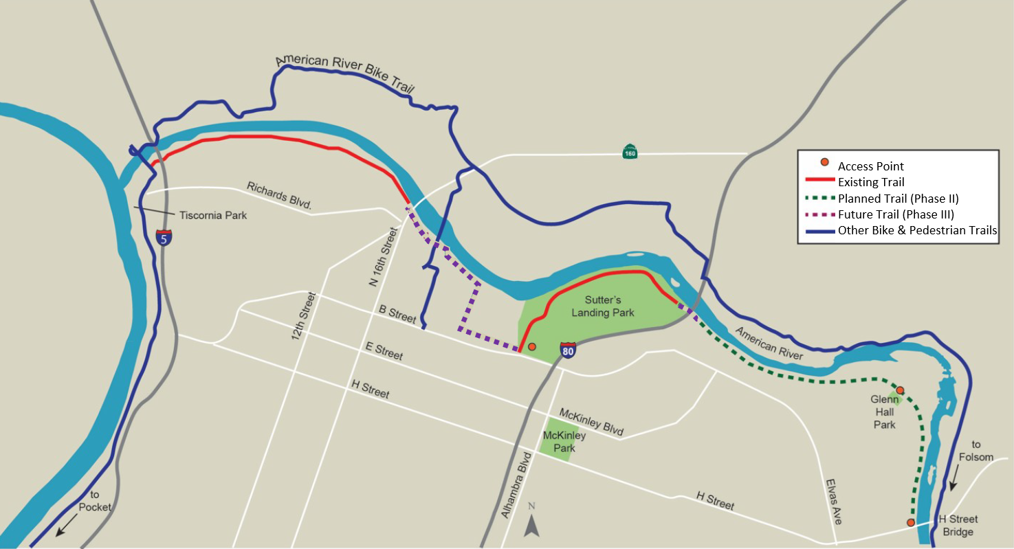
Map of Two Rivers Trail
The City of Sacramento is working toward the completion of a continuous network of paved, accessible, multi-use trails that connect the existing Sacramento River and American River parkways. The Two Rivers Trail Project is an important piece of the evolution of the City’s trail system. Named for its origin at the confluence of the Sacramento and American Rivers, the Project began to take shape in 2001 with the completion of a Two Rivers Trail Concept Plan.
When complete, Two Rivers Trail will connect the system of pedestrian- and bicycle-friendly trails along both sides of the Sacramento and American Rivers.
Two Rivers Trail Components
- Phase I (Completed in 2006) – Levee-top trail between Tiscornia Park and State Route 160
- Sutter’s Landing (Completed in 2016) – An additional segment of trail along the south bank of the American River from 28th Street to the eastern edge of Sutter’s Landing Park (completed as part of the American River Parkway Enhancements Project)
- Phase II (Construction Underway in 2024) – An additional 2.4 miles of trail that will connect to the existing County trail at the H Street Bridge, and ends at the UPRR eastern right-of-way line.
- Phase III (Planning and Design Underway in 2024) – Additional trail segments and trail amenities that will close many of the existing gaps between the Phase I and Phase II trail segments.
- Phase IV (Feasibility Assessment Underway in 2024) – Trail crossing of the westerly UPRR tracks.
Phase III - Planning Underway
Two Rivers Trail Phase III will close the majority of gaps within the trail system, bringing the City one step closer to realizing the vision that was established over 20 years ago – a continuous network of multi-use trails that provides recreation and transportation options for the region.
Phase III Schedule
- Project Approval and Environmental Review – Underway (Fall 2024 – Spring 2025)
- Development of Plans and Specifications – Spring 2025 – Fall 2026
- Construction – Fall 2026 (depending on funding)
Phase III Components
- Connect Two Rivers Trail Phase II (currently under construction) with the eastern limits of the existing Sutter’s Landing Trail
- Create a new trail segment from 28th Street to the “landfill loop” (east of UPRR)
- Connect the Sac Northern Trail to Two Rivers Phase I
- Provide conceptual designs and early feasibility assessments for a crossing of the westerly UPRR tracks
Public Management Process Area
As planning and design work on Phase III get underway, the project team will work closely with City residents, particularly those in areas surrounding the trails, to present project details and information and obtain public input.
If you are interested in learning more about future project meetings and presentations, please e-mail us at tworiverstrail@cityofsacramento.org
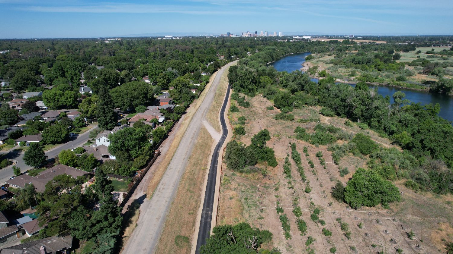
Phase II - Under Construction
After years of design, planning and public engagement, Two Rivers Trail Phase II broke ground early in 2024. The first mile and a half of trail has been completed, with the remaining segments anticipated to be completed by the end of the year with the adjacent USACE Bank Protection and Department of Utilities Sump Station projects.
Phase II will include more than two miles of paved accessible pathway connecting the trail system from the H Street Bridge to just east of Sutter’s Landing Park and the Business 80 freeway.
Provided below are previous public meeting presentations to provide additional background about Phase II components.
 open_in_full
Two Rivers Trail Overview
Overall Project Benefits
The Two Rivers Trail system will offer several benefits to the local community and surrounding area.
Safety
Based on data from the National Recreation and Parks Associations and local parks and law enforcement staff, bike trails tend to reduce crime by cleaning up landscape and attracting users to the trail for recreation and transportation. Additionally, the trail system integrates Crime Prevention Through Environmental Design – commonly known as CPTED
Property Value
According to the National Association of Home Builders, trails are the most desired community amenity that homeowners seek when buying a home. In fact, neighborhood trails located in various cities have reported an increase in property value ranging from 2 to 5 percent.
Project-Related Documents
Provided below are a series of important documents and reports created either as part of the evolution of the Two Rivers Trail project, or in alignment with the vision of the project.
Reports and Documents
Questions & Additional Information
Phone: (916) 303-2086
Email: tworiverstrail@cityofsacramento.org
ON THIS PAGE